Tuesday, March 31, 2015

Chapter 12: A New Home in a Far Away Place


As summer approached in 1886, George Armstrong was busily making plans for his move to what was then eastern Piute County.  While his efforts at homesteading in Juab County had not gone well, he had acquired enough means to join with partner, Robert Pope, in purchasing a horse powered threshing machine. Upon arriving in Rabbit Valley, he would not only homestead 160 acres (1), but would also do custom threshing in the fall.

While George Armstrong saw this move as a chance to start over – an opportunity and an adventure - it’s hard to imagine Aurilla being enthused.  Nephi was the “gathering place” for her family – both the Sperrys and the Sidwells.  Even though it had been over 10 years since the first permanent settlers had made their homes along the Fremont River, Rabbit Valley was still a faraway place in a relatively unknown part of Utah Territory.  One hundred and twenty miles in our day of smooth highways and comfortable automobiles does not seem like a long distance, but in 1886, this was at least 10 days of hard travel –  rough roads in an even rougher wagon, riding a horse, or walking. While the Indian threat was minimal, travelers were still vulnerable to the rouge outlaw – be it white man or brown – not to mention the ever changing weather.  Reluctant to take his family into such an unknown situation, the summer of 1886, George left Aurilla and the kids and went to Rabbit Valley to get a start on their new home.

 Having been unsuccessful in their attempts to make a home in Chicken Creek, it seems likely that Aurilla (pregnant with a baby girl – Margaret Myra – due in September)  would have taken her 4 small children, George Alvin age 7, William Lamont, 5, Mary Leerolen, 4 and Thomas Edwin, 1, and moved back to Nephi to be close to friends and family during the months that George A. was gone.

The slow thrashing process may well have kept George away until late fall or early winter. I know of no record that mentions rather he was present for Margaret's birth on September 20th, but surely it was a happy day when he arrived back with his family in Nephi.  While Aurilla may not have been an enthusiastic listener, not wanting to think about the move, George surely would have had a lot of information to share about their new home and what the family could expect when they all moved south the following spring.  Eager to hear the news was his side kick half-brother, Peter James Christensen.   Even though he was five years younger than George, Peter was at a similar place in his life - married with 4 small children.  While Aurilla may have been hesitant, Peter wanted to know more. While Peter did not join George immediately, three years later, in 1890, he also left Nephi and moved to Rabbit Valley.  (Peter’s 5th child was born in Nephi in the fall of 1889, and his 6th child was born in April, 1891, in Loa, Utah. Considering the snow on the mountain passes, the family must have been living in Loa by the fall of 1890 at the latest)

As spring of 1887 approached, Aurilla and George prepared to leave.  It must have been a tearful good-bye as the Sperry, Sidwell, and Peterson families gathered around the small family as they headed south out of town with their one wagon, 4 horses and a cow headed to a faraway place in what was then one of the most remote parts of the Utah Territory. (Chappell family history has it that the family left Nephi with one wagon, four horses and a cow – History of George and Aurilla Sperry Family, Blue book p. 13) Surely there were tears.  Nephi, their beloved home looked over by the towering Mt. Nebo, would forever be a special place for George and Aurilla.  Considering the annual return visits to Nephi that were so much a part of the lives of this couple, it is very possible that George’s bride refused to make the move until George had promised he’d bring her back each year to spend time with dear family and friends.

Traveling with his wife and 4 small children, it is unlikely the young family averaged more than 15 miles a day.  Having lived in Chicken Creek southwest of Levan, the first miles of the journey between Nephi and Levan would have been a road familiar to everyone in the family.  However as the trek headed south the dry, sagebrush wilderness between Levan and Gunnison was surely lonely.  The 40 miles between Levan and Gunnison would have taken a couple of days and the family would have camped along the trail for at least two nights.  The Sevier River meandering through the bottom country would have provided water and forage for the animals and maybe a chance for the young boys to catch a fish.

From Gunnison south to Salina and on to Sigurd, the well-established communities along the Sevier River would have provided well maintained roads and plenty of resources for the immigrants.  However, as they left the Sevier and turned up Kings Meadow Canyon and headed southeast into the mountains, the wagon trail would have become much more primitive and the way more difficult.  After several miles of steady climb to near the top of King’s Meadow Canyon, the road turned south towards Bear Valley.  The narrow, winding canyon surrounded by dense pinion and juniper forest eventually gave way to a broad sage brush valley just below the quaking aspen and pine forests of the eastern slope of Monroe Mountain.  Soon the difficult climb ended and a welcome descent led them out of Bear Valley into Burrville nestled on the northern edge of Grass Valley. 

Just south of Burrville, a favorite camp site was Cedar Grove.  This somewhat unusual collection of mountain juniper grouped into a well-defined grove of trees near the valley floor provided protection from wind and storm but was also close to the stream flowing through the valley and its associated animal forage.   At near 7000 feet in elevation, their camp in Grass Valley would have been cool at night even in mid-summer.   While Grass Valley sloped gently south along Otter Creek, their destination was even further east – further away from what little civilization existed at the time in south Central Utah!

Fish Lake Mountain rose in impressive fashion to the east and north.  The western edge of the Parker Mountain, while not as high as its neighbor to the north, had steep slopes that rose up quickly providing an imposing obstacle of their own.   As they worked their way along the rough road toward the top, George knew this would be the last real challenge in their journey.  Topping out at near 8500 feet the view was magnificent.  Mountain ranges rising up to the brilliant blue sky could be seen in all directions.  To the west, the plateaus of the Monroe; and beyond, the jagged peaks of the Tushers.  To the north, the Fish Lake High Tops with their few scattered pine, sloped steeply to the east suggesting the mountain bowl holding the lake for which the mountain was named. To the north, on the distant horizon, much to their delight, Mt Nebo!  Familiar friend!  Maybe they were not so far away as they had thought!

Looking south, the rolling sage brush hills seemed to go on and on until the distant pine forests turned the horizon navy blue.  Moving east, the dark horizon rose quickly to a flat topped mountain – the imposing and impressive Boulder Mountain.  Looking directly east, another flat topped mountain – smaller but just as tall – stood separated and alone - the gap between the two suggesting they were part of the same until separated by millions of years of erosion.  The red, yellow and white foot hills of the Boulder and the imposing red cliffs of the southern Thousand Lake foreshadowed the rugged canyon country of the Colorado Plateau.  Even further east, the land of John Wesley Powell and the still relatively unknown Henry Mountains completed the vista.  At the base of the Thousand Lake Mountain, they could see a suggestion of a valley.  Following one more night camped on the rolling Parker; the family would have gotten their first good look at their new home.  An article that appeared in the evening copy of the Deseret News dated April 2, 1880, written by a Mr. Wheeler provides a contemporary opinion of what the Chappells found as they descended  the western hills: 

This valley is said to be bout seventy-three hundred feet above the sea level.  It is a new moon shaped basin surrounded by high mountains.  The north, east and sought mountains are covered with pine and quaking asp, while the foothills in every direction are covered with nut and pinion pine and volcanic rock.  The most excellent dry pinion-pine fires enjoyed here by the poorest family would break the wealthy in Salt Lake. 
The people here are living in a very scattered condition, each family on their respective quarter section.  There are sixty or seventy families in the valley and we heard of only one forty-acre man, and they say he is looking for more.  A town has been laid out on the west side of the valley on a beautiful, dry gravelly bench, but as all are quarter section men, they are following the dictates of the law to secure their titles…
There are two sawmills in running order with extensive groves of the very finest timber in Utah inviting us to bring our axes and use them as it requires no great strain of foresight to see that not far distant an extensive business will be done here in making and hauling lumber…
The valley is very well watered and Fish Lake, now frozen over is a natural reservoir on a large scale and abounds with trout, great quantities of which are caught every spring by the Indians. 
Elias H. Blackburn has recently been appointed Bishop in place of George S. Rust and with his first counselor, Franklin SW. Young, is trying to get the Ward organized… the people have built two school houses and two more are talked of…
Wheat, oats and barley have been raised and ripened three years now, also potatoes, turnips, beets, etc.  Many of the people are jubilant over the prospects of huge copper works as copper is said to exist by the acre about thirty miles below the valley on the Fremont River.
We have located our quarter section of land, and as you, the reader can’t all do the same, and as we have to go clearing of the sage brush lest we get too far behind those who have already gotten from five to thirty acres of grain, we best be obliged to go. (Deseret News, (Salt Lake City), April 2, 1880, p.2, as quoted in Chappell, Settlement and Development of Wayne County, Utah to 1900)
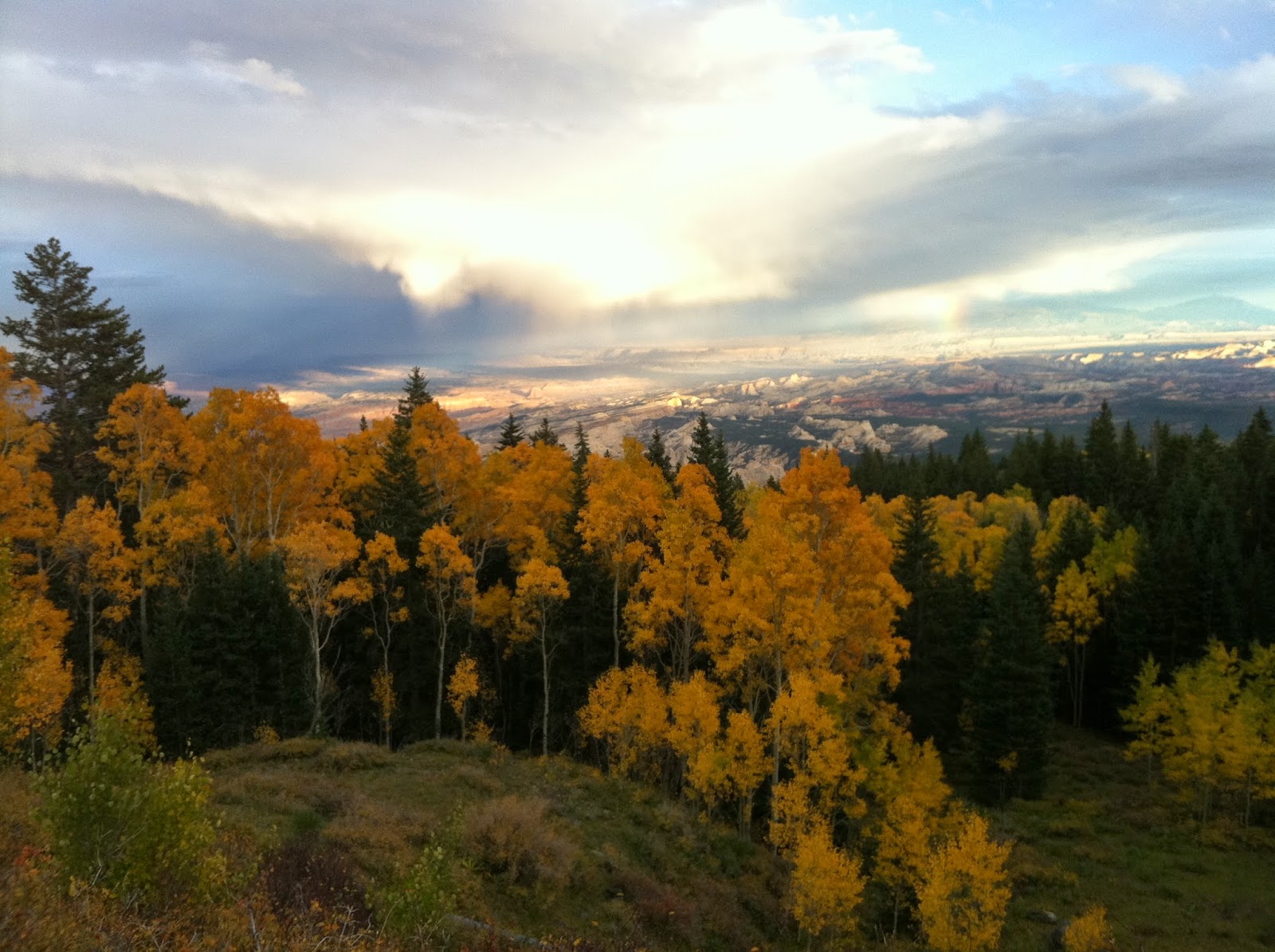
View of Rabbit Valley from foothills east of Lyman. Looking Northwest with Loa across the valley. 

The sage brush valley was several miles across and perhaps 15 miles long.  At over 11000 feet, the surrounding mountains obscured the fact that the valley floor was over 7000 feet and one of the highest locations in Utah to be cultivated. Dominating the western half of the valley were two large streams of water.  Meandering through the more middle part of the valley, surround by willows and meadows flowed the Fremont River.   Bubbling out of the ground to the northwest, Spring Creek paralleled the Fremont on the west until the two streams joined several miles south.  Road Creek, while smaller than the other two, entered the valley from the west, its deep canyon suggesting the quite stream was not always so passive.    Leaving Rabbit Valley, the reinforced Fremont carved a winding canyon through the encroaching Parker Mountain foothills before opening up into another flat valley at the base of the Boulder.  Red Lake (shallow precursor to the Bicknell Bottoms) was a temporary resting place for the Fremont where it gathered more strength from several springs, Pine Creek and Government Creek before plunging into rugged red canyons on its way to the Colorado.
Looking across the valley toward Thousand Lake Mountain - view from south of Loa 

To the east and the west of the streams, the sage brush flats, home to the many jack rabbits for which the valley was named, were in the process of being converted into checkered farms of barley and hay. The valley floor was void of any trees other than a few willows along the streams. While in many ways windswept and desolate, the valley did have the luxury of a generous and constant water supply.  The abundant water and forage had attracted the cattlemen who first built permanent dwellings in the valley in 1875 (2)  

When George and Aurilla arrived the spring of 1887, the local communities were still in their early stages of development.   Unlike other Mormon settlement operations in which individuals and families were called by church leaders to colonize specific locations , those who settled the towns along the Fremont came on their own.  Like the young Chappell family searching for a new start, people had come from all over Utah to settle this new and wild local.  Initially spread out and hap hazard, the early settlers homesteaded and built their homes on the part of the valley that was most pleasing to them. (See Appendix A)  

Most early settlers were members of the LDS Church and in December of 1877 there were enough people living in the area to establish the Fremont Valley Branch of the Grass Valley Ward of the Sevier Stake of Zion of the Church of Jesus Christ of Latter-Day Saints. (3) Concerned about the scattered nature of the early settlements, as early as 1878 LDS leaders out of Salt Lake City began encouraging the people to establish themselves into organized communities (4) Later that year the scattered members of the area were organized into the Fremont River Ward and as the people began to come together in communities other wards were formed.  The Thurber Ward was organized in 1882 and the Loa and Fremont Wards were organized in June of 1887 (5), likely not long after the Chappell family arrived. 

Having spent a good part of the previous year in Rabbit Valley, it’s likely George had already had filed on the land that would be his homestead about three miles directly east of Loa at the edge of the Thousand Lake foothills.  With a farm under way, he now needed a home for his family.  Loa seemed to be the best option.  By 1887 the town of Loa was well established.  Fremont, to the north, was the largest town in the upper valley – and would remain so until about 1895 (6) – but Loa was fast becoming the economic hub of the upper Fremont.   The town site had been surveyed in 1880 and dedicated in 1885 and many families were settling on its five and six acre blocks. (7)  Having come from an established Mormon community, it’s likely Aurilla preferred living in a town rather than settling on the homestead as so many others had done.   While not Nephi, Loa did provide some of the amenities Aurilla had left behind such as established streets and lots, schools and neighbors, and proximity to church activities and stores.  Another important factor in 1887 would have been the lack of a clean, consistent water source on the east side of the valley.   No perennial streams flowing off the west side of Thousand Lake Mountain reached the valley floor and irrigation ditches had their obvious draw backs.  Loa would be their home for the next 8 years.
View from Thousand Lake Mountain - Loa is on far side of the Valley
Current areal view of Rabbit Valley 

1.      Summary of The Homestead Act of 1862:  The Homestead Act of 1862 was a law passed by the U.S. Congress and signed by President Abraham Lincoln on May 20, 1862.   It provided for the transfer of 160 acres (65 hectares) of unoccupied public land to each homesteader on payment of a nominal fee after five years of residence.   A homesteader had  to be the head of a household or at least 21 years of age to claim a 160 acre parcel of land.  Land could also be acquired after six months of residence at $1.25 an acre. http://www.homesteadhomemaking.com/the-homestead-act-of-1862/
2.      Aldus Chappell, The Settlement and Development of Wayne County, Utah, to 1900; Master’s Thesis, Brigham Young University, 1975, pp. 11-12
3.      Loa Utah Stake 1893-1993, published 1993, p. 3
4.      Miriam B. Murphy, A History of Wayne County, 1999, Utah State Historical Society, p. 108
5.      Loa Utah Stake 1893-1993 p. 4
6.      Anne Snow, Rainbow Views: A History of Wayne County; Daughters of Utah Pioneers of Wayne County; 1953, Art City Publishing Co., Springville, Utah; Fourth Edition, 1985.  p.177
7.      Snow, p. 197

 Appendix A,
Aldus Chappell, The Settlement and Development of Wayne County, Utah, to 1900; Master’s Thesis, Brigham Young University, 1975, pp. 21-22
In analyzing the settlement pattern of these early pioneers to Rabbit Valley, several interesting points became apparent.  For one thing there was no pattern of system to their settling.  Each came to build a home and looked for the most attractive (to him anyway) place to build.  The things that each looked for were fertile land, plentiful water supply, and suitable appearance.  As nearly as can be ascertained, these early settlers were live stock men and were attracted to the abundant forage and adequate water supply, so each chose the place that suited him best.
Another point that indicated a lack of an organized system is the fact that very few came from the same place.  Thurber came from Spanish Fork, McClellan from Payson, Allreds from Spring City, Morrells, from Emery County, Blackburn from Minersville, Paces from Dixie, and so on, each coming to make a home because the outside was getting too crowded, and each coming irrespective of the others.  For some it was the spirit of adventure and pioneering, others had experienced failures and were looking for new opportunities, a chance to “start over”. For some it was a combination of reasons. 
There was really no need of an organized settlement with a fort and people banding closely together, as was usually the case.  In most places in these early days a Fort was necessary for protection against the Indians but there was no serious menace here.  The families were scattered throughout the valley and it wasn’t until a few years later that townsites were surveyed and people started moving closer together. 

The Navajo Indians generally did not come this far north in their raids, and the Utes were so weakened after the Walker War that they did not operate in this valley.  There was only one band of Piutes, under the leadership of Tueank and these were peaceful. 

Sunday, March 29, 2015

Chapter 11: The Early History of Rabbit Valley and the Upper Fremont River


The early Mormon settlement of Utah, as was most of the West, centered around sources of water and irrigable lands. The many rivers and streams flowing from the canyons along the western slope of the Wasatch Mountains provided the largest and most productive agricultural areas for the early settlers. Moving south from the Wasatch, dividing the dry sage brush desert to the west from the red rock canyon country to the east, a series of valleys bordered by mountain ranges oriented in a general north and south direction provided addition locations for settlement. Parley P. Pratt, LDS Apostle, led an exploratory expedition south in the late fall and winter of 1849-50 traveling about 800 miles down and back what is roughly the rout of current Interstate Highway 15. Soon settlements were started in the areas the expedition identified as favorable. In 1851 the communities of Nephi, Fillmore, Parowan and Cedar City were all established. Before the end of the decade, the towns of Beaver, Washington, Scipio and Gunnison had been settled; and by the end of the 1860’s communities up and down the Sevier River were growing and thriving. (1) However, to the east of the Sevier River the land remained very much a mystery.
Rough terrain along the lower Fremont
 South-eastern Utah, including what would become Wayne County, was one of the most inaccessible and least known areas in the Utah Territory until the mid-1870’s. The Ute and Paiute successors to the ancient Fremont people knew the plateau country, but their knowledge was unavailable to the mapmakers of the day. Geologist Herbert E. Gregory, noting the remoteness of the Colorado Plateau, wrote: ”As late as 1868 the official military map of Utah shows in outline the topography of the Green and Grand river valleys and the course of the Colorado, but the country north of the Grand Canyon between the river and the Utah High Plateaus is represented by a “blank space.” (2)


 Prior to the arrival of the white explorers and settlers, this “blank space” was well known to many Native America tribes. Archaeologists believe the area of current Wayne County has been continuously inhabited since about 8000 BC. (3)The reliable water source of the Fremont River had been a magnet for settlers long before the Mormons arrived. Early hunters and gatherers inhabited the area for several thousand years BC. Later farmers and gatherers described as Ancestral Pueblo (Anasazi) and Fremont made their homes along the Fremont River and surrounding area. The Fremont culture, a unique culture whose artifacts are mostly found along the Fremont River drainage of Wayne County reached its peak between A.D. 900 and 1000. However, by about 1250 A.D., their culture began to disappear. (4)
The Grand Gallery, Canyonlands National Park, eastern Wayne County
Petroglyphs along the Fremont River, Capital Reef NP

 Coinciding with the decline of the Fremont culture, was the arrival of the Numic-speaking people – ancestors of the Paiute, Shoshone and Ute tribes. Some believe the Numa evolved from the Anasazi and Fremont, while other believe they immigrated from the western or northern Great Basin. (5) Oral traditions among the Paiute and Ute would suggest their ancestors were living in these regions even before the immigration of the Ancestral Pueblo or Fremont. (6) Regardless of their origins, when the first white men arrived in the region in the mid 1800’s, the Numa-speaking tribes had lived there continuously for almost 1000 years. (7) Prominent among the Numa-speaking people were the Utes.
Paiute Indians

 Rabbit Valley and the Fremont River was just a small part of the vast area the Utes called home that extended from Central Utah to the eastern slope of the Rockies, north into Wyoming and south to New Mexico. (8) Largely a hunter/gatherer culture, they moved according to food sources and weather. They hunted the abundant deer, elk, antelope, bear, mountain sheep and small game found throughout their lands. Buffalo and buffalo hides were also a major source of food, shelter and clothing. Tribal oral traditions have buffalo residing in Rabbit Valley as late as 1840 (9). They fished the streams and frequented Fishlake. They gathered fruit, nuts, seeds, berries and roots. (10)
Ute Indian Families

 The Utes “were scattered out over the land in family groups or bands,” Coneth wrote. The extended family was “the center of Ute life,” and there was no “chief” over all of the Utes. Those with special knowledge, skills, or wisdom on respect, and often served in leadership positions during times of need. “In their search for food and shelter, each band traveled over a wide area, usually in route from the desert or plains lowland in winter, to the mountains and plateaus in summer”. These scattered groups came together at various times for meetings, dances, and other amusement, and marriages. The Ute groups in the Fish Lake area became closely associated with the Southern Piute groups that also utilized the lake and its surrounding forests and streams. (11) (See appendix A at end of chapter)
Ute Indians

 The first contact these native peoples had with those of European descent would have been in the late 1500’s or early 1600’s as the Spanish led expeditions into their territory. With this contact came the introduction of the horse which were thought to have reached the Utes north of the Colorado River by the mid 1600’s. (12) Father Escalante passed through much of the Ute territory during his 1776 expedition, however, he never passed within a 100 miles of the rugged valleys of the Fremont. (13) Later the Spanish Trail – a highway of commerce between the pueblos of New Mexico with the haciendas of Southern California used from the early 1800’s through about 1846 – brought large pack trains of mules from Santa Fe loaded with woolen blankets and other products headed west to Los Angeles to be exchanged for horses and mules. Later in the fall, large herds of animals procured in California would pass back over the trail headed east. While the trail did not enter the valleys along the Fremont River, a route usually used only in late summer did pass by Fishlake. The returning traders would have come up Grass Valley along Otter Creek before climbing up onto the plateau country overlooking Rabbit Valley about 15 miles to the southeast. From there they passed by Fishlake, through Seven Mile then joined the main route in Salina Canyon. (14) While we have no written record of white men entering Rabbit Valley from the Spanish Trail, we can assume at least a few curious travelers would have ventured therein.
Mule trains on the Old Spanish Trail


While we have no written records of Euroamericans visiting Rabbit Valley from the Spanish Trail, John C. Fremont, prominent western explorer, did pass through during the winter of 1853-54 in his search for a possible route for the transcontinental railway. (15) The first Mormon explorations into the area were during the Blackhawk war of the 1860’s as Mormon militia from the established communities to the west, pursued marauding bands toward their safe havens in the east. In September of 1865, General Warren S. Snow, along with 103 militia were involved in a battle near present day Bicknell Bottoms in what has been referred to as the “Battle of Red Lake”. (See Appendix B at the end of this chapter). The following June or July, General William B. Pace led another group of men through Rabbit Valley and on to the rugged Capital Reef National Park area in pursuit of Indians who had stolen cattle along the Sevier (16). Later that same summer, a company of men under the command of Captain James Andrus came up from the south and passed along the northern slope of the Boulder Mountain before passing over Parker Mountain and on to Grass Valley. (17)
Cathedral Valley east of Thousand Lake Mountain. It is thought John C. Fremont passed through here on his way to Rabbit Valley on the west side of Thousand Lake Mountain. 
Bicknell Bottoms along the upper Fremont River. Location of the Battle of Red Lake. 

 The major hostilities of the Black Hawk war having ended, in the early summer of 1873 Brigham Young sent a group of 19 men explore the land southeast of the Sevier Valley, meet with the local Indians and gain permission to establish communities. After meeting with the local Indians at Fishlake and Grass Valley, the company traveled over the mountain and down into Rabbit Valley. The little valley with not one, but two streams meandering through grassy meadows made an impression on the travelers. The abundant water, plentiful game, and friendly Indians were happy findings. One of the men, A.K. Thurber liked the area around present day Bicknell so much, he named it after himself. On the return trip, at Cedar Grove, just south of present day Burrville, a peace treaty was negotiated. Soon after, President Young called for settlements to be established. Thus opened up a new, all be it remote, location for those looking for a new start, or to establish a place of their own. (18)

 1. http://www.uen.org/utah_history_encyclopedia/
 2. Miriam B. Murphy, A History of Wayne Conty, p. 53, 1999, Utah State Historical Society
3. Rosemary Sucec, Fulfilling Destinies, Sustaining Lives: The Landscape of the Waterpocket Fold. An Ethnographic Overview and Assessment of the American Indian Histories and Resource Uses within Capital Reef National Park, Utah, and on Lands Surrounding It. 2006, p. 40. National Park Service, U.S. Department of Interior.
4. Murphy p. 41
5. Sucec, p. 97
6. Sucec p. 100
7. Sucec p. 97
8. Murphy p. 45 : “The area the Utes called home was a vast 225,000-square mile domain extending from the area of the present towns of Fillmore, Utah to Colorado Springs, CO, and from Baggs, Wyoming, to Abiquiu , New Mexico. Some hunters even ranged beyond these limits, according to tribal historian, Fred A Conetah. This land, with its many different environments, provided the Utes with “sources of food, clothing, and weapons, places of refuge from raiding neighbors…sanctuary from summer heat and …shelter from winter cold, meeting grounds for councils and ceremonies, and sacred spots for healing the sick.” The Utes hunted the abundant wild game of the area: deer, antelope, buffalo, elk, bear, mountain sheep and smaller animals. They fished in the streams throughout the territory, and the resources of Fish Lake were well known to them. They gathered fruit, nuts, seeds, and berries and edible roots and learned the healing properties of other plants. Some Utes farmed, but more often they obtained corn, beans, and squash by trading with Pueblo peoples in the Southwest

9. Sucec p. 110
10. Murphy p.45
11. Murphy p.45
12. Sucec p. 113
13. Sucec p.117
14. Sucec p. 119
15. Susec p. 131
16. Susec p. 159
17. Murphy p. 61
18. Murphy p. 62

Appendix A:

 Miriam B. Murphy, A History of Wayne Conty, p. 53, 1999, Utah State Historical Society

 Pg 46: “Southern Paiutes and Utes living here before eh arrival of the Euro-Americans adapted to the semi-arid environment…through a settlement pattern called “transhumance’. To best utilize the wide range of plant and animal resources available seasonally at different elevations, these people moved camp regularly. Seeds were gathered from grasses…and animals such as antelope, mountain sheep, and rabbit were hunted.” “For shelter the Paiutes traditionally utilized windbreaks, brush shelters, and more substantial winter dwellings made of juniper or aspen posts with wild ryegrass as filler, held in place by bark and /or willow boughs. Some winter houses were slightly excavated pit houses’. Whether temporary or semi-permanent, these dwellings were located near a water source. The Southern Paiutes used a ‘highly developed’ variety of basketry, ‘which served their needs in transporting both wild and cultivated plant foods’. Many family groups made Fish Lake a regular stop on their foraging excursions, especially during the spring when the fish were spawning. In their winter camps they passed on their rich oral tradition, including myths, tales, a very large repertoire of songs for many occasions, and proverbs. Their traditional dance was the circle or round dance. From the Utes they borrowed the bear and turkey dances.”

 Appendix B:

 History of Indian Depredations in Utah, 1919, Peter Gottfredson. Pg 167 Battle at Red Lake, Snow, Taylor and Frandsen Wounded.

“Nearly two months had passed since there had been any serious outbreak. But Indians wre prowling round Circleville, and it was reported that they had a rendezvous somewhere near Fish Lake, east of Sevier Valley. General Warren S. Snow with 103 men went up the River as far as Circleville; he had with him colonel John Ivie’s company of cavalry from Mount Pleasant, and Captain N.S. Beache’s company from Manti, with some recruits from other companies; they went to investigate the condition of affairs and arrived in Circleville September 18, 1865. On the 19 they marched up the east fork of the Sevier to Clover Flat, where they encamped for the night. There they got onto the Indian’s trail, which they followed over the plateau between Grass and Rabbit Valleys. Night overtook them before reaching the latter valley; it was raining and very dark; they made camp in the head of a very rough canyon. Early next morning (September 21st) Ezra Shoemaker and another man went out to reconnoiter; they found the track of a pony which had come within half a mile of camp and turned back; they reported what the had seen. The company then worked their way down the canyon. When they reached the flat country, at a small lake or pond called Red Lake, near Thousand Lake Mountain, they made a halt. General Snow and Col. Ivie went up a black, rock ridge to get a view of the country and its surroundings. When near the top, Col Ivie saw a ramrod wiggling behind a brush only a few paces away, and exclaimed “There they are,” when a volley was fired from ambush, one bullet hitting and seriously wounding General Snow in the shoulder. The men retreated to the company, when a general battle ensued; the Indians firing from ambush on top of the hill. The Indians over-shot - the bullets singing over the heads of the soldiers, striking in the water, fairly making it boil. Orson Taylor of Richfield received a serious gun-shot wound in the side. George Frandsen of Mount Pleasant, while concealed in a gully, trying to get a shot at an Indian he had seen, received a bullet high I the forehead, the missile plowing through his hair and filling his eyes and face with blood, but it caused no further injury. A short retreat was ordered for the purpose of getting flanking movements on the savages, when it was noticed that one of the pack animals had been left behind. Ezra Shoemaker of Manti and another man went back, and in the midst of a shower of bullets from the enemy recovered the animal with the pack. The fighting continued till night and several Indians were killed. The militia crossed back over the mountain in the night to Grass Valley and made camp. Next day they marched down King’s Meadow Canyon to Glennwood, where they separated and returned to their respective homes.”

Chapter 10: Early Marriage Years in Juab County

Aurilla's Aunt Sophi's home in Nephi
It’s not known where George and Aurilla had their first home.  A January marriage would have made it difficult to build something new, and unless George A had constructed a cabin or other home the summer and fall before their wedding, it’s most likely the young couple took up residence in one of their parents’ homes or that of another relative.   Relying on the help of family, they would have begun their new life together.   While winter employment may have been hard to come by, with spring approaching, the industrious young husband would not have had trouble finding work in growing Nephi. 

Young George Armstrong Christensen, as he was known before his marriage, afterward elected to take the name of his biological father, George Chappell. 

By the time George and Aurilla Chappell were married in January 1879, Nephi had become a bustling community central to the social and economic life of the surround region.  The arrival of the railroad later that year in May of 1879 along with the discovery of gypsum at the mouth of Salt Creek Canyon solidified the small city’s position as the economic hub of Juab County.  Coal had been discovered in San Pete County and in 1880, a rail to Nephi was completed greatly enhancing the already improving economic circumstance of the town. 

Having plenty of work and being near family, the young couple remained in Nephi for the next four years.  As they neared their first anniversary, Aurilla was becoming large with child.  With her mother, sisters and cousins near to support and assist, Aurilla gave birth to a son, George Alvin, born December 29, 1879.  Another son, William Lamont, blessed their marriage on August 3, 1881.  Less than a year later, much to Aurilla’s delight, a little girl, Mary Lerolen, joined their little family on July 13, 1882.

Having provided for his family by working various jobs, George A began looking to establish a place of his own.  He wanted to work on his own place; to have his own land.  While most of the water resources and irrigable land in eastern Juab County had long since been settled, George and others in the area found an opportunity to develop some land southwest of Nephi in an area called Chicken Creek.

The original town of Chicken Creek was settled in 1860 about 3 miles southwest of present day Levan.  However, within just a few years, it became evident the soil was sub-optimal and the location too far away from the water needed for irrigation.   In 1867, LDS Apostle Erastus Snow recommended the residents of Chicken Creek relocate to the present site of Levan.  By the time George moved to the area looking for a start of their own, all that was left was a few foundations and rock fireplaces.  (A History of Juab County, Centeniall Series, p. 49.)
Sevier River in Juab County

While the exact location of the homestead is unknown, the nearby newly established town of Mills may well have been the place.  Located further west near where Chicken Creek joined the Sevier River, this community provided new opportunities for settlement in eastern Juab County in the 1880’s. According the George’s younger half-brother, Parley P. Christensen, their father Peter Christensen had a homestead in Mills which he worked from about 1880 to 1888 (History of Parly P. Christensen as found on Familysearch.com). It would stand to reason that George would join his father in developing this new area of settlement.   In 1877 a Mr. Winigar settled just west of the Sevier River about 24 miles southwest of Nephi.  The area had plenty of flat land, grass, and water for irrigation. However, the newly arriving settlers soon found the area had its problems. The soil was alkaline, snakes abundant and the mosquitos intolerable.  Soon the town was called Suckertown because of the mospuitos. Many early residents lived in Dugouts or cabins. There was a local general store owned by John Williams, for whom nearby John Williams Canyon was named.( http://www.ghosttowns.com/states/ut/mills.ht) Between 1883 and 1896, the location was officially listed as the Wellington Branch of the LDS Church.  (A History of Juab County, Centeniall Series, p. 53.)
Dugout Cabin (picture from nearby Sanpete County)

Like so many others settling in the area, George found the proposition of carving out a home in this land passed over for decades by earlier pioneers, difficult at best, impossible at worst.  Like his parents and grandparents before him, the first order of business for George A was to get the limited water available in this dry land, onto the sagebrush flats – flats that with hard work and consistent effort could one day be lovely fields of green hay and golden oats. 

While water coming from the eastern mountains was a source for irrigation, this source was limited.  The earliest settlers of Chicken Creek, and later Levan, had placed dams and ditches many miles upstream.  Spring runoff would have supplied the western reaches of Chicken Creek, but by mid-June water flow to any western projects would have been minimal at best.  However, a constant and abundant source of local water was the Sevier River.  

Water in the desert
Early history of Juab County describes how the settlers in the Mills area created irrigation systems to bring water from the Sevier River onto the nearby land.  The biggest challenge facing them was the creation of diversions to back the water up and into surrounding canals.  Big rocks, logs, and whatever else they could conceive of were pushed into the river to try and slow its flow.  The river was deep and dangerous as the brave men worked to keep their canals flowing against the varying ebs and flows of the largest river in southern Utah.  (Keith N. Worthington, Sadie H. Greenalgh, Fred J. Chapman, They Left a Record, 1851-1978) 

I the spring of 1880, George and his friend, Amos Chase, were working on their diversion works when Amos was tragically killed. According to recorded history by Amos's daughter, Ina P. Chase Garrett, George and Amos were working on their dam when a pole broke that was holding the log on which they were standing. Amos was thrown into the river. The date was May 26 and the Sevier River was running high and cold. Amos was not a good swimmer and was swept away and drowned. George jumped in to try and save his friend and almost lost his own life in the effort.  (See addendum at the end of this chapter)

Losing his friend was very difficult for George, but he continued to try and make a go of it. About 1884, George moved Aurilla and their three small children to their new home along Chicken Creek. Joining them in their new home, on July 21, 1885, their third son, Thomas Edwin, was born.

After years of hard work, realizing the futility of the task, and tiring of the inhospitable surroundings, George began looking elsewhere for a place to call his own. Now, approaching forty years since his Chappell relatives had arrived in Utah in 1849, land suitable for farming was becoming harder and harder to find.  The 1862 Homestead Act allowed that any citizen over age 21 could homestead up to 160 acres of public land by paying a filing fee and making certain improvements during a five-year period.  The challenge at hand was to find land to homestead.

Articles in the Deseret News in the spring of 1880 and again in 1881, described new land for settling in Rabbit Valley in eastern Piute County.  Franklin Wheeler Young, nephew of Brigham Young, authored the first article and described the abundance of pinyon trees for fuel, water for irrigation, and land for homesteading finishing his article wondering why people would remain in Salt Lake City  and the older settlements when they could  take up land for farms in the Fremont Valley “with but little exertion”.   The 1881 article by Elias Hicks Blackburn, the local bishop, expressed the need for skilled craftsmen such as shoemakers, blacksmiths and tanners.  (Miriam B. Murphy, A History of Wayne County, 1999, Utah State Historical Society, pp. 104-5) In the fall of 1886, George Armstrong Chappell headed south. 


Addendum: The following history was posted on the web site, familysearch.org:

typed from handwritten notes found in the effects of Ina P. Chase Garrett, a daughter of Amos Chase Amos Chase, son of John Darwin Chase and Pricilla McHenry Chase, was born 17 September 1841 at Nauvoo, Illinois. Amos’ mother didn’t come to Utah but when the Saints left Nauvoo she was persuaded by her people to go back to her parents’ home in Iowa and stay with them. She took her young son, James, with her. His father joined the Mormon Battalion and left Amos with his Aunt Amy Bigler (his father’s sister) and her husband Jacob G. Bigler, who raised him as their own child and brought him to Utah in 1847 or ‘48. He lived with them until his father married Almira Higgins — later his father married Elizabeth Tuttle, after which Amos lived for awhile at Nephi, Utah; then to Moroni, then to Ephraim, and then to Carson City, Nevada, the family having been called to go there. When Amos was a young boy his father went on a mission to England. Amos ran the farm and looked after the family for two and one half years. He married Eleanor Coolidge 2 November 1863, they lived in Moroni until after their first child, John H. Chase, was born; from Moroni they went to Payson and lived there until after their third child, James Chase, was born. Their second child Amos Jr. died at Payson when he was about 10 months old. From Payson he moved his family on a ranch on the Sevier River about 10 miles southwest of Juab. Here he struggled for ten years to provide for his family, during which time four more children were born to them; Solomon D., Ellen Elizabeth, Sisson C., and Eliza Ann. Here he met with an accident 26 May 1880, about 10 a.m., which caused his death. While he and George Chappel were putting in a dam in the Sevier River in order to get water on their land, a pole broke which was holding the log they were standing on and he was thrown into the river. Being a poor swimmer and the water was very high and very cold, he was unable to battle successfully with the stream and was drowned. Mr. Chappel went in the water to search for him, but almost lost his life in trying to save his friend. A large searching party from Nephi of 30 men with ropes and hooks dredged the river for 3 miles between two dams for 9 days in hopes of rescuing the body, but did not find it and they abandoned the search and all returned home but two. The body finally arose and was found by his half brother, Sisson A. Chase. His wife and children had left the ranch for Nephi and were at Juab when the word reached them that the body was found. He was brought to Nephi for burial, services were held at his Uncle Jacob G. Bigler’s home. His youngest daughter, Ina Pricilla was born 23 July 1880, not quite two months after her father’s death. *Edited March 2018 by Suzanne Juanita Garrett Iverson, granddaughter of Phil Garrett; originally typed by Phil Garrett, copy still in his Book of Remembrance; minor changes to spelling and grammar were made to improve readability.